Klaas Wynne Mapping
Orienteering maps are made with the latest version of OCAD, using LiDAR data combined with aerial photography, to ISOM 2017-2 or ISSprOM 2019-2 standards. Where possible other data sources are used such as infrared photography & vector maps as well as old maps. A base map is typically produced in about a day but extensive surveying is required for the important details. Surveying is carried out using modern GNSS with an accuracy of ~0.5m under forest canopy.
Some recent examples showing what I can do are the Doon Hill & Fairy Knowe forest map (major update of a map, 2025), the Knockmountain forest map (new map, 2025), and the Kelvin South urban sprint map (new map, 2025). My use of modern positioning technology is described in GNSS for orienteering mapping. If you think I can assist you in your orienteering mapping project, please contact me at
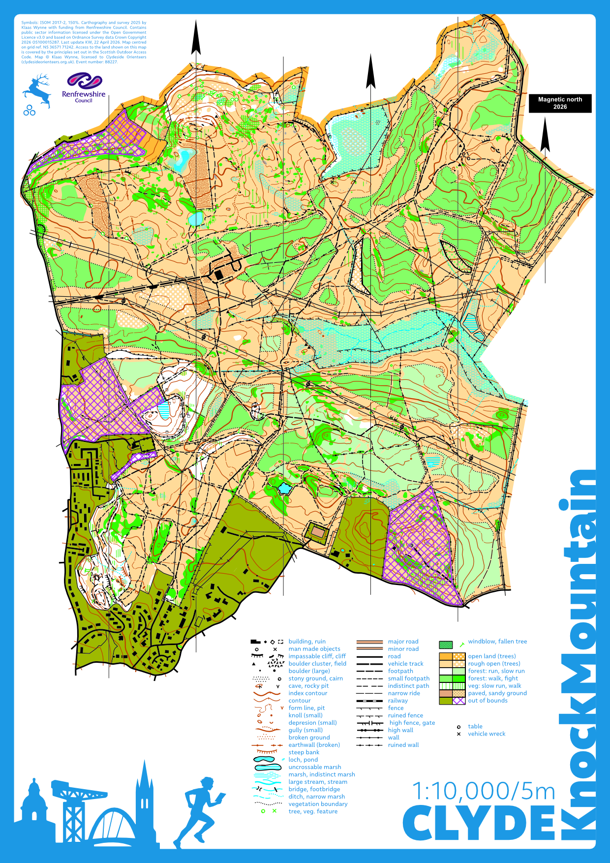
An exemplar recent new forest map of Knockmountain near Kilmalcolm made for CLYDE with funding from Renfrewshire Council in 2025.
All orienteering maps and courses in and around Glasgow
2026
- Bar Hill and Twechar: an ongoing re-map of the Bar Hill area and a new urban sprint map of the neighbouring village Twechar funded by Scottish Orienteering. The map will be used by CLYDE as well as
- School maps: new school orienteering maps of Gleniffer HS and Hermitage PS & Park made for Scottish Orienteering.
- Balloch Castle Country Park: update of 2016 map, expansion into Whinney Hill for CLYDE, and installation of permanent orienteering courses for Countryside Ranger, Greenspace, West Dunbartonshire Council.
2025
- Doon Hill & Fairy Knowe: Major update and expansion of the lovely CLYDE Doone Hill & Fairy Knowe map. The map was first used for the Junior European Cup 2025 (JEC) and Veteran Home International 2025 (VHI) forest relay races on 5 October 2025.
- Kelvin South urban sprint map: Major update and expansion to include the main (Gilmorehill) campus of the University of Glasgow, North Kelvinside up to Maryhill Road, Kelvingrove Park, and extends east to (and slightly over) the M8 (ISSprOM 2019-2). To be used for the 26th Glasgow Parks Champs No.966. Kelvingrove Park Sun 30 November, 2025 (joint STAG/CLYDE).
- Knockmountain: New map for CLYDE of an area north of Kilmacolm near Glasgow funded by Renfrewshire Council.
In 2025, I also helped plan courses with Ben Stansfield for day 4 of the Scottish Six Days, Balfour Forest Long on 31 July 2025.

Out planning at Balfour for the 2025 Scottish Six Days with Chris Low, Dave Coustick, Roger Coombs, and Ben Stansfield.
2024
- Auchengillan: updated for CLYDE.
- Croy Hill: Major update of existing CLYDE map to be used for SoSOL in September 2024.
- Dougalston: new map for CLYDE.
- Emmenerdennen: The Emmerdennen near Emmen in the Netherlands is a sandy area covered in forest. Special challenge is the flatness compared to Scottish terrain requiring special care in editing contour lines. Map for Hoc'93, in progress, used for a training event in 2023 and hopefully to be used for a bigger event in the near future.
- Kelvin North: Glasgow's Garscube Campus, Dawsholm Park, Kelvindale, the Wyndford, Botanic Gardens orienteering maps (2022-24) Major ISSprOM 2019-2 redraw and extension for 2024.
- Mugdock: Update of Carbeth area and all veg updated using NDVD.
- Rouken Glen: New map of Rouken Glen Park and golf course for CLYDE used March '24.
2023
- Mugdock: Completely redrawn 2023 map of Mugdock Country Park, Dumbrock Woods, Craigallian Estate, and Carbeth.
- West End: Gilmorehill and Kelvingrove Park orienteering map
2022
- M8dness: ISSprOM 2019-2 map of Garnethill and Dundasvale Court area in Glasgow
- Mugdock: Mugdock park, Dumbrock Woods, and Carbeth orienteering maps
- Necropolis: Glasgow Necropolis Long course (pdf, 0.7MB), only accesible under SOAC.
- Available as MapRun6 course in the folder UK/Scotland/Glasgow/CLYDE/Necropolis Long PXAC.
Hill O
- Campsies: Campsies West orienteering maps including Dumgoyne course
- Dalry Moor: "update" of a map from 1983 using modern techniques. In progress... (2023).
- Kilpatrick hills: Kilpatrick hills orienteering map including Slacks course
Older projects
- Ardinning: Loch Ardinning (pdf, 1.4MB) north of Glasgow, only accessible under SOAC. Originally made for STAG but never used (2021).
- South side: Glasgow's Linn Park, Netherton Braes, Cathkin Braes, Fernbraes, Castlemilk Park, Croft Park, and King's Park and including Glasgow South Side Original City Marathon course. (2021).